KT’s new real-time bus tracker is live! Here’s how to use it.
“Where is my bus?”
It’s the number one question our riders have – and for good reason. Since Kitsap Transit’s previous bus-tracking app ceased operation at the end of 2024, our riders have been understandably frustrated about this missing function.
Today, we’re excited to announce the launch of our new real-time bus-tracking tool! The tool shows the real-time location, crowdedness and estimated arrival time of your bus at the next few stops. Riders can also plan trips, view bus or ferry schedules, and find stops near their location!
The tracker is the next step in Kitsap Transit’s ongoing effort to improve our real-time rider information. Earlier this month, we debuted a new rider alert system that allows riders to sign up for personalized email or text message alerts when their bus or ferry is disrupted. We’re also working on a project that would let riders text or call a phone number to receive information about when their bus will arrive at their stop.
These upgrades take time, and we appreciate your patience while we work out the kinks! If you have feedback, you can reach us here.
A few notes: the KT Tracker map shows real-time bus locations. We are working to add real-time ferry locations soon, but they will not be available at launch. If you would like to see the location of your ferry, you can use apps like MarineTraffic or VesselFinder. In addition, we are working to launch our Google real-time data feed so that the public can find real-time bus and ferry locations in third-party apps like Google Maps, Apple Maps, Transit, Moovit and Citymapper. Real-time information for our On-Demand services is available through the Ride Pingo app.
How to use Kitsap Transit Tracker
Here are some tips to get you started using the tracker:
Select your route(s) from the drop-down
Select the “View Routes” button in the top left (it looks like a road). From there, pick which routes you’d like to track from the dropdown list. The route will be indicated by a colored line and a pin with the route number. Buses are indicated by small circles with a bus icon.

Buses are represented on the map by a circular bus icon. The color of the bus will match the color of the route pattern line. The route number is displayed in a small oval pin.
2. Select a stop or a bus to see real-time predictions
Clicking on a bus or a stop on the map will bring up a table with real-time stop predictions as well as arrival times based on the schedule (“SCH”). When you select a stop, you’ll see the estimated arrival times for buses at that stop (under the “Next EST” tab).
When you select a bus, you’ll see a list of upcoming stops and estimated arrival times. The estimated arrival time is only for buses arriving within the next 30 minutes. If the bus is delayed and stopped somewhere, the system may not provide an estimated arrival time; instead it will show delayed (“DLY”).

You can view the next estimated bus arrival times at a certain stop by selecting that stop on the map.
3. See how busy your bus is and view your bus schedule
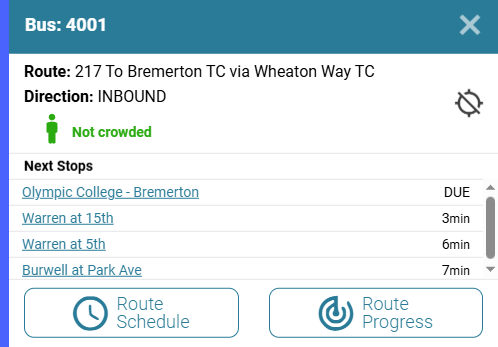
Clicking on a bus will display how crowded the bus is and the estimated arrival time at the next few stops.
Clicking on a bus will also indicate how busy that bus is, using terms like “Not crowded,” “Somewhat crowded,” or “Very crowded.”
You can view a bus schedule by selecting “Route schedule,” when a bus is selected, or under the “Schedule” tab when a stop is selected.
4. Find a stop near you
Selecting the bus stop icon (the middle button in the top-left of the map) will open the “Find a Stop” menu. You can see nearby stops by clicking “Find stops near me,” and allowing KT Tracker to use your location. Alternatively, you can enter your stop number if you know it, or pick a route, direction, and stop from the dropdown list.
What do “inbound” and “outbound” mean?
Inbound and outbound are transit terms used to describe the direction a bus is traveling. An “inbound” bus is a bus traveling towards one of Kitsap Transit’s central hubs (usually a transit center or ferry terminal). “Outbound” buses are traveling away from these hubs.
What if I don’t know my stop number?
You’re not alone! Kitsap Transit has over 1200 stops in our system, some of which have the same cross-street names. To find your stop number, first pick your route from the “View Routes” menu, and then select your stop on the map. The stop ID will be listed above the real-time arrival information.
Kitsap Transit sends rider alerts that sometimes include stop numbers. If you’re not sure if your stop is affected by a closed stop or detour, using the KT Tracker is a great way to check!
Extra tip: When signing up for Kitsap Transit rider alerts, make sure to select the bus stops you use to receive stop-specific alerts!

Selecting a bus stop will show you that stop’s name, number and next estimated bus arrival.
5. Use the trip planner
To plan a trip, select the “Plan a Trip” icon (it looks like a small pointer on a map). Enter your origin and destination address, or select them on the map, pick a departure option, and then click “OK.” The app will then suggest a route based on your selections.
Questions? Contact Kitsap Transit Customer Service at (360) 377-2877 for assistance.
Find suggested bus routes and estimated travel times under the “Plan a Trip” menu.